
Asinara Trails: Complete Hiking Guide

Nine themed trails, over 60 kilometers of routes, and elevation gains ranging from a few centimeters to 408 meters: the Asinara National Park offers a network of trails capable of satisfying both the casual visitor and the experienced hiker. The main challenge for those planning a visit is not finding a trail, but choosing the right one based on available time, physical fitness, and specific interests.
Tackling the island without a plan risks resulting in wasted days or, worse, hikes undertaken at the wrong time of day or in the wrong months, with concrete consequences related to the scarce availability of water and the lack of shade. This guide describes every official trail in the park, organized by geographic area, with data on length, elevation gain, bikeability, and historical-natural points of interest. By the end, you will know exactly which route to choose and how to structure a multi-day visit.

How to Organize Your Visit: The Main Road and the Three Areas
Asinara is crossed by a concrete road of about 25 km, connecting Fornelli in the southern part to Cala d'Oliva further north. This main artery is defined as the island's backbone: traveling along it, one can cross the main natural environments and the historically inhabited centers—Fornelli, Tumbarino, La Reale, and Cala d'Oliva.
Connecting to this road are the themed trails, most of which are built on dirt roads, existing mule tracks, or routes historically used for pastoral activities.
For a complete exploration, the recommended organization involves at least three days, each dedicated to one of the three main areas:
-
Fornelli Area (south)
-
Cala Reale Area (center)
-
Cala d'Oliva Area (north)
The recommended seasons are spring and autumn. This is not generic advice but an operational recommendation: the strong sunlight, high temperatures, limited water availability, and lack of shaded areas make hiking and cycling strongly discouraged during the summer months.
Fornelli Area: Three Trails Among Granite, History, and Nature
Granite Trail
The Granite Trail stretches for 11.2 km, takes about 3 hours and 30 minutes, and has a maximum elevation gain of 75 meters. It is largely bikeable, with access from the Fornelli Pier.
The route runs along the dirt road east of the pier square. At the first back-dune pond, take the left, heading inland until you intersect the road connecting the Fornelli super-prison to the Santa Maria facility. From the top of the hill, you descend toward Punta Barbarossa, where a small body of water serves as a winter refuge for ducks and herons. The trail's name derives from the constant presence of granite along the entire route.
The path runs along the coast between coves, Mediterranean scrub, and small temporary ponds, up to the two beaches of Punta Li Giorri, where it becomes more rugged, encountering ancient granite quarries. In the final section, at Cala Sant'Andrea, the trail skirts the brackish water body and the integral protection zone, returning to the paved road toward the starting point.
Castellaccio Trail
At 8.3 km and about 2 hours and 40 minutes of walking time, the Castellaccio Trail has the most challenging elevation gain among the Fornelli area routes: 212 meters. It is partially bikeable, with access from the Fornelli Pier.
From the pier, proceed along the paved road toward the Fornelli prison, passing through disused structures of the prison administration—sentry boxes, officers' quarters, laundry, and water troughs. After about two kilometers, near a hill with wide visibility over Cala della Reale, turn left onto an old mule track following the signs for the castle.
About one kilometer on, among large spurge and thorny broom plants, a natural spring marks the bicycle parking area. From here, the trail becomes more challenging. Along this stretch, encounters with wild goats and herds of mouflons are frequent—a detail that makes this trail particularly suitable for wildlife observation enthusiasts. The castle ruin is reached in about half an hour from the spring.
From the Castellaccio, a ruined medieval structure, the view extends from the Fornelli Strait to Piana Island, all the way to Stintino and the entire Nurra peninsula. On days of good visibility, the ancient coastal defense structures built during the period of Saracen raids are also visible.
Water Trail
The Water Trail is the most accessible route in the Fornelli area: 6.9 km, about 2 hours, maximum elevation gain of only 42 meters, entirely bikeable and loop-shaped, with access from the Fornelli Visitor Center square.
The theme of the route is clear from the name: water in its various forms—marine, freshwater, brackish ponds, small bridges, wells, troughs, springs, small dams, and reservoirs—accompanies the entire route, which is easy and accessible to anyone on foot or by bicycle.
About a third of the way in, the Punta Salippi Outpost—an ancient watchtower structure restored to its original color—represents an ideal stopping point for a swim. The path continues toward the open sea, then briefly climbs toward the earthen dam that collects waters from the granite massif of Castellaccio, until reaching the aqueduct structures and the Fornelli prison.
A historically relevant detail: in the plain lies a small chapel with a collapsed hemispherical dome and a quadrangular enclosure that delimits a small cemetery—the only remaining traces of the First World War prisoner camp.

Cala Reale Area: Nature, Memory, and the White Donkey
Mouflon Trail
The Mouflon Trail extends for 6.1 km, takes about 2 hours, with a maximum elevation gain of 50 meters. It is not bikeable, and the access point is the Tumbarino Wildlife Observatory.
This route is described as one of the most significant from a naturalistic perspective on the entire island. In addition to mouflons, it is easy to observe wild boars, ravens, Sardinian partridges, and colonies of gulls and crested cormorants nesting on the islets of Cala di Scombro di Dentro. The trail is considered an ideal place for birdwatching, especially in spring and autumn, when it is possible to follow the passage of migratory species between Europe and Africa.
Along the route, in the buildings of the former Tumbarino prison branch, is the Wildlife Observatory of the Asinara National Park, active in bird ringing activities and censuses.
Memory Trail
At 5.5 km and about 1 hour and 20 minutes of walking time, the Memory Trail has an almost non-existent elevation gain (0.1 m), is loop-shaped, and entirely bikeable. Access is by following the signs from the Cala Reale Visitor Center.
This trail is described as a journey back in time, discovering the ancient and recent human traces of the island. Along the way, one encounters the Austro-Hungarian Chapel, the Campo Faro complex—a small penitentiary settlement—the old barracks, and the Italian cemetery, where the soldiers who fell on Asinara in 1916 rest.
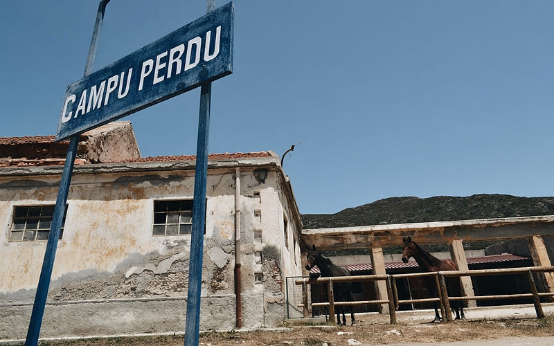
The route continues to Campu Perdu, a former prison branch with an agricultural vocation, where it is possible to visit the Domus de Janas and the Austro-Hungarian Ossuary, which holds the remains of over 5,000 prisoners from the First World War. Along the trail is also the Park's Sea Observatory, which houses the Asinara Marine Animal Rescue Center.
White Donkey Trail
The White Donkey Trail measures 7.8 km, takes about 3 hours, with practically no elevation gain (0.1 m). It is not bikeable; access follows the signs from the Cala Reale Visitor Center.
As the name suggests, this is the route with the highest probability of spotting the white donkey, visible here in small family groups, sometimes together with gray donkeys. Along the way, one encounters the structures of the Maritime Health Station and the former Trabuccato prison branch. Inland, some officers' quarters can be found, while toward the sea emerge the agricultural structures of the Winery and the Trabuccato coastal tower.
Nature Trail
The Nature Trail is the shortest and most accessible route in the entire network: 2 km, about 1 hour, elevation gain of 0 meters, not bikeable, with access from the Cala Reale Visitor Center.
This trail stands out for a unique feature: it is designed to be usable by the blind, with rest areas equipped with Braille texts and interactive tactile stations. The first 350 meters are also accessible to people with motor disabilities in wheelchairs, with a picnic area at the end of the dedicated section. A rope handrail guides the visitor for about 830 meters along a circular route that returns to the starting point.
Along the way, two branches can be found: one toward the sea, the other toward the "Mediterranean Garden" themed route.

Cala d'Oliva Area: The Longest and Most Panoramic Trails
Holm Oak Trail
The Holm Oak Trail is one of the most challenging routes on the island: 13.7 km, about 3 hours and 20 minutes, with a maximum elevation gain of 408 meters—corresponding to the highest point on Asinara. It is a loop route with a small detour toward Punta della Scomunica, not bikeable, with access from the former Cala d'Oliva Officers' Barracks.
From the Memory Observatory, one climbs toward the highest hills, in the direction of the Case Bianche Branch, encountering springs, troughs, terraces of Ligurian origin, and valleys once cultivated as vegetable gardens. Immediately after the Case Bianche hill, the landscape changes radically, reminiscent of the inland areas of Sardinia.
Here begins the section dedicated to the holm oak, among springs, water channels, chestnut trees, and rest areas built with the contribution of inmates and the Sardinia Forestry Authority. At the summit are the Forestry Guardhouse and the Elighe Mannu Botanical Observatory, recently renovated.
The climb toward Punta della Scomunica, the highest point on the island, offers a view described as unique. The trail continues toward Punta Maestra Serre, entering an area often covered in fog and low clouds, populated by wild goats, before descending toward the ruins of Cuile Zonca and returning to Cala d'Oliva.
Lighthouse Trail
At 17.9 km and about 5 hours and 30 minutes, the Lighthouse Trail is the longest route in the entire hiking network, with a maximum elevation gain of 120 meters. It is not bikeable; access is from the village of Cala d'Oliva.
From the upper part of the village, following the signs for Punta Sabina, one reaches the main dirt road. Cala dei Ponzesi is visible from above about 1 km from the start of the trail, with a short variant leading to the bay. The road to Punta dello Scorno runs along the cliffs at elevation, among large spurge bushes.
This trail leads to Cala d'Arena, described as the most beautiful beach on the island. Due to its delicate environmental balance, the turquoise inlet, the dunes, and the juniper grove behind are now an integral reserve: access and swimming are not permitted.
Passing the coastal tower, one reaches the Punta dello Scorno lighthouse, described as a reference point for all Sardinia's maritime routes. A detour leads to the ruins of the former Signal Station, an old Air Force meteorological station, now used as a perch by birds of prey. The route, developed on ancient military mule tracks, is technically easy but significantly long.
Cala Sabina Trail
The shortest of the Cala d'Oliva trails: 1.3 km, about 50 minutes, maximum elevation gain of 10 meters, not bikeable, with access from the village of Cala d'Oliva.
The path starts near the small cemetery of Cala d'Oliva and leads easily to the beach of Cala dei Ponzesi, whose name derives from the historical frequentation by fishermen from Ponza. The route follows an old mule track along the coast.
Trabuccato Trail
The Trabuccato Trail measures 6.5 km, takes about 1 hour and 45 minutes, with a maximum elevation gain of 62 meters. It is an out-and-back route, not bikeable, with access from Cala Murighessa.
From the beach of Cala Murighessa (also called "of the inmates"), the dirt trail heads toward Cala Reale following the signs for Trabuccato. At Cala le Soriane, the path forks: the coastal side is reserved for experienced hikers, while the upper route is accessible to everyone. Opposite Cala Barche Napoletane, continue along the coast toward Cala Trabuccato, rejoining the paved road near the former Trabuccato prison branch, and finally reaching Cala Reale.
The nine trails of the Asinara National Park offer options for every level of physical fitness and every interest, from the challenging trek toward Punta della Scomunica to the total accessibility of the Nature Trail. The choice of route should be based on three main factors: available time, the geographic area you wish to explore, and the prevailing element of interest—historical, wildlife, or landscape.
Planning your visit in spring or autumn, dividing the exploration into at least three days dedicated to the different areas, allows you to make the most of this unique trail network. With growing attention to slow tourism and mindful hiking, it is likely that Asinara's trails will continue to attract an increasing number of visitors interested in an experience that combines nature, history, and memory.

If you liked this article and you feel like going on an excursion to the Asinara National Park, contact us: we organize guided tours and excursions to Asinara with the lowest prices in Stintino for this summer 2025
How much it costs to visit Asinara?
With us the landing fee at the Asinara National Park is included in the price and if you choose the half-day excursion you will have a free tasting of Sardinian products.

VISITA GUIDATA ALL'ASINARA IN CATAMARANO
Giornata Intera
09:30 - 17:30
Dal 1 Maggio al 30 Giugno
Catamarano in esclusiva 1200€
a persona 100€ € (90 € ridotto)
Luglio
Catamarano in esclusiva: 1500€
a persona 125 € (115€ ridotto)
Agosto
Catamarano in esclusiva: 1620€
a persona 135 € (125€ ridotto)
Settembre
Catamarano in esclusiva: 1500€
a persona 125€ € (115€ ridotto)
Ottobre
Catamarano in esclusiva: 1200€
a persona 100€ € (90 € ridotto)

Frequently Asked Questions
What is the longest trail in the Asinara National Park?
The Lighthouse Trail is the longest, at 17.9 km and about 5 hours and 30 minutes of walking time. It leads to Cala d'Arena, considered the most beautiful beach on the island, and to the Punta dello Scorno lighthouse.
Which trail is best for seeing the white donkey?
The White Donkey Trail, which starts from the Cala Reale Visitor Center, offers the highest probability of sightings, with the donkeys often visible in small family groups along the 7.8 km route.
Is there a trail accessible for people with disabilities?
Yes, the Nature Trail has been designed to be usable by blind people, with Braille texts and tactile stations. The first 350 meters are also wheelchair-accessible, with a dedicated picnic area at the end of that section.
What is the best time of year to hike the Asinara trails?
Spring and autumn are the recommended seasons. During the summer months, the strong sunlight, high temperatures, scarce water availability, and lack of shade make hiking strongly discouraged.
Which trail reaches the highest point on the island?
The Holm Oak Trail reaches Punta della Scomunica, at 408 meters, the highest point on Asinara, through a 13.7 km route that also passes the Elighe Mannu Botanical Observatory.
Can you visit Cala d'Arena?
No, access and swimming at Cala d'Arena are not permitted because the area—including the beach, dunes, and the juniper grove behind—is classified as an integral reserve due to its delicate environmental balance.
Which trails allow you to see remains of the First World War prisoner camp?
The Water Trail, in the Fornelli area, leads to a collapsed chapel and a small cemetery, the only traces of the camp. The Memory Trail, in the Cala Reale area, reaches the Austro-Hungarian Ossuary with the remains of over 5,000 prisoners.

